2-8-18 CableMap-02 - Copy Courtesy: Gateway House
2 August 2018

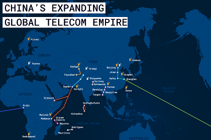
Version 2: Mapping China’s global telecom empire

This version of the Gateway House Map on China’s Expanding Global Telecom Empire identifies some more telecommunication assets -- optic-fibre and satellite ground stations -- that Beijing is working on in South and Central America, Africa, Myanmar, the Indian Ocean Region and mainland China besides the existing ones, such as the Pakistan East Africa Cable Express (PEACE). It shows the direction China’s investment is taking, its diplomatic overtures and the larger geopolitical implications of its growing telecom empire

aashna-china Courtesy: Gateway House
14 May 2018

Gwadar: trade hub or military asset?

China’s ostensible intentions are to turn Gwadar port into a focal point of the China Pakistan Economic Corridor. But the geography of the region is a major stumbling block in the realisation of these ambitions and raises questions about the project’s underlying motives

CableMap-web Courtesy: Gateway House
5 April 2018

Version 1: China’s strategic edge in covert communications

China is steadily deploying state-of-the-art communications systems to connect its strategic and economic assets in Asia. It is then linkingthe Asian mainland to Africa, and Africa to South America. The investment spree is rapidly making Beijing a major player in global telecommunications – and ‘informationisation warfare’.

corridorsmap2 Courtesy: Gateway House
11 July 2013

Asia’s Strategic Corridors to India

The map – Asia’s Strategic Corridors to India – has emerged from Gateway House’s study of India’s strategic links with other parts of Asia. It highlights the progress India has made in forging multiple links with six strategic regions – Central Asia, West Asia, East Africa, South-East Asia, East Asia, and our immediate neighbourhood